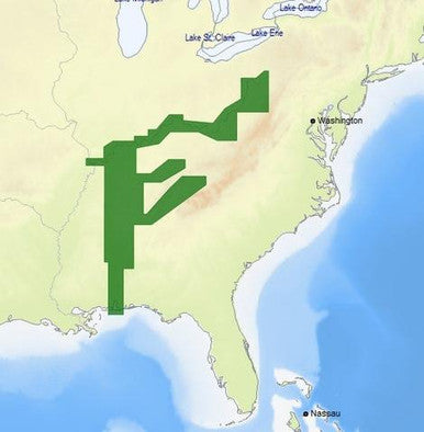
The C-MAP M-NA-D039 4D microSD is a top - notch navigation solution for US rivers in Ohio, Tennessee - Tombigbee, and Cumberland. Model: M - NA - D039 - MS. It offers full - feature vector charts that let you toggle views to see animated tidal streams and currents. You can check tidal heights when planning your trip to avoid surprises. Dynamic navigational aids help you plan your route. The exclusive Dynamic Raster gives a traditional 'paper chart' look with access to buoy and light details. Enjoy stunning 3D views of land and bottom contours, high - resolution satellite imagery for coastal navigation, and detailed bathy data for gamefish. It also provides sport fishing data, easy routing, interactive tides and currents, aerial photos, guardian alarms, and multi - language charts. C - MAP 4D MAX+ combines award - winning vector data with exclusive features, enhancing cruising, fishing, and sailing experiences. It's compatible with major chart plotter brands like Furuno, Humminbird, Raymarine, and Standard Horizon. It offers local and wide coverage globally at an affordable price and allows adding future value - added data. A lower - cost C - MAP 4D MAX option is available for Raymarine Dragonfly Displays.

Using the C - MAP M - NA - D039 4D microSD is easy. First, insert the card into your compatible chart plotter. When planning a trip, use the full - feature vector charts to check tidal streams, currents, and heights. You can toggle different views to get the information you need. For coastal navigation, switch to the satellite view for better situational awareness. When fishing, refer to the sport fishing data for tips and regulations. When using the easy routing feature, make sure to input your vessel information accurately. As for maintenance, keep the microSD card in a dry and cool place. Avoid exposing it to extreme temperatures or moisture. If you notice any issues with the card, check the connection in your chart plotter. If problems persist, contact the manufacturer for support. Also, remember to update the card regularly to access the latest data and features.